Quick reference
The essential facts to save before cell service fades.
Group leader cue card
Read these decisions aloud and regroup at the suspension bridge. The sources are beside the instructions so you can verify them—not buried at the end.
Driving arrival from Hoodsport
- Take SR 119 west.Continue a little more than 9 miles to the T with Forest Road 24.
- At the T, turn left.Continue 1.7 miles to the end of the pavement.
- Stay on gravel for 3.7 miles.At the next junction, turn right.
- Continue 1.2 miles to Staircase.Use the signed visitor/day-use lot on the right, across from the campground.
Leader call: “The phone pin gets us close; park signs choose the actual lot.”
Why trust this: WTA gives the complete turn-by-turn sequence and approach coordinate. NPS independently confirms access via gravel Forest Service Road 24. Road and gate status from NPS controls.
Hike decisions & where not to turn
- Cross the road bridge from the ranger area.Start on the Staircase Rapids Nature Trail; use optional short spurs only if posted open.
- Stay on the loop beside the river.The route described here travels clockwise and upriver first.
- Critical turn at about 0.8 mile: take the trail right.Cross the suspension bridge. Do not continue upriver onto Four Stream Trail or any signed closed route.
- After the suspension bridge, follow the trail downstream.Continue just over a mile toward the ranger station and parking area to close the loop.
At the bridge, regroup and say: “Across once, then downstream—not upriver.”
Why trust this: WTA supplies the 0.8-mile right turn and downstream return narrative. The official NPS area map establishes the ranger-area orientation; NPS trail conditions control closures.
On-site authority winsA ranger instruction, gate, cone or closure sign overrides this guide, its GPX and every phone map.
Full route map
This north-up diagram is generated from the project GPX. Solid blue is the main loop; dashed branches are the two out-and-back spurs.
Swipe sideways to read the enlarged offline map.
- River Viewpoint, if posted openCross the road bridge to the trailhead, take the short viewpoint spur only if signs permit it, then return.
- Big Cedar, if posted openFollow the Rapids Nature Trail and use the signed cedar spur only if signs permit it. The fallen and living cedars share the endpoint.
- Rapids upriverReturn to the main trail and continue beside the river toward Staircase Rapids.
- Cross the suspension bridgePause for the river view, cross once, and turn downriver on the opposite bank.
- Close the loopFollow the return trail toward the ranger station and day-use parking.
Navigation warningCurrent NPS reopening pages name the Rapids Loop but do not expressly name the two short spurs. Use a spur only if posted open. After the suspension bridge, use the downstream return leg; the map never overrides a closure.
Turn source: WTA’s clockwise route narrative says to turn right at about 0.8 mile, cross the suspension bridge, and then follow the trail downstream to the ranger station and parking. Verify what is open on the NPS trail-conditions page.
Staircase ranger-station area
Use this unmodified NPS diagram to orient from the parking lot. It is a local facilities map—not a complete depiction of the northern loop or suspension bridge.
Swipe sideways to read the enlarged offline map.

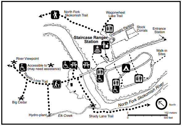
Use it on arrival
- Use the visitor/day-use lot across from the campground.
- Orient toward the ranger station and the road bridge.
- The Rapids trailhead is directly across the bridge.
- Follow posted Rapids Loop signs; use either short spur only if it is posted open.
- A cone, closure sign or ranger instruction overrides this guide.
Access, parking & facilities
Getting there
- Navigation/approach pin
- 47.5158, -123.3300; follow signs to the visitor/day-use lot.
- GPX trace start
- Approximately 47.51543, -123.32939, inside the day-use area.
- From Hoodsport
- Take SR 119 west a little more than 9 miles. Turn left where it T’s with FR 24; continue 1.7 miles until the pavement ends, 3.7 miles on gravel to the junction, right at that junction, then 1.2 miles to Staircase.
- Parking
- Use the visitor/day-use lot on the right across from the campground. Use only signed overflow or ranger-directed alternatives.
Arrival sources: WTA turn-by-turn directions; NPS current road/access status; NPS parking and ranger-area map.
Before walking
- Cell service can be unreliable; save this guide and the GPX offline.
- Check the Staircase road/gate before departure.
- Bring an accepted federal pass or an accepted card/digital pass; Olympic National Park is cashless.
- Restrooms and picnic areas are shown on the official area map.
- Pets and bicycles are not permitted on park trails.
Lake Cushman area & optional stops
Practical advice: protect the Staircase parking window first, then consider lake stops while backtracking toward Hoodsport.
Swipe sideways to read the enlarged offline map.

Lake Cushman Viewpoint
Drive-up lake and mountain view at Tacoma Power recreation marker 3.
Community-mapped navigation pin: 47.4501653, -123.2103532
Open viewpoint directionsSkokomish Park
Optional paid lake day-use stop at 7211 N Lake Cushman Road. Seasonal opening, access and fees can change.
Check the operator’s current informationReturn-stop sources: The official Tacoma Power recreation map identifies Lake Cushman Viewpoint as marker 3. Skokomish Park’s operator controls current access, season and fees.
Safety & dated conditions
Snapshot checked Aug. 30, 2026NPS reports the Staircase developed area and Rapids Loop open; all other Staircase trails remain closed. The current NPS pages do not expressly name the River Viewpoint or Big Cedar spurs. Use a spur only if posted open and recheck NPS sources immediately before travel.
Burn-scar hazards
Stay on the open trail. Wind, heavy rain and storms can increase falling-tree, rolling-rock, unstable-ground, landslide and debris-flow risk.
NPS reopening and burn-scar guidanceClosed continuations
Do not continue onto Four Stream, North Fork Skokomish beyond the loop, Wagonwheel, Flapjack or another signed closed route.
NPS trail conditionsRabid-bat notice
NPS reported a rabid bat near Staircase Bridge on Aug. 9, 2026. Never touch a bat. After possible contact, seek prompt medical and local public-health advice even if no bite is visible.
NPS public-health noticeBefore leaving
- Check NPS road, gate and trail status.
- Check weather, wind, smoke and active fire information.
- Save this page, the GPX and the official area map offline.
- Bring water, food, layers, rain protection and footwear for wet roots.
- Follow posted closures and ranger instructions over every saved map.
Sources & authority
Complete link set for this specific drive, hike and return route. Official sources control access and safety; community and map sources supplement them.
NPS current conditionsControlling park-wide alerts, Staircase access, road, facilities and open-area status.
NPS trail conditionsControlling trail closures and dated field conditions.
NPS fire conditionsBear Gulch recovery, closure boundaries and current fire information.
NPS Visiting StaircaseOfficial access-road context, weather dependency and area overview.
NPS Staircase area brochureOfficial area map, loop facts, facilities and park rules.
NPS ranger-station map imageUnmodified official parking, campground, bridge and trailhead diagram.
NPS Big Cedar TreeApproach, accessibility, fallen 14-foot cedar and living cedar.
NPS reopening and burn-scar guidanceJuly 2026 reopening scope and post-fire hazards.
NPS rabid-bat noticeAugust 2026 Staircase incident and public-health instructions.
NPS entrance feesCurrent fees and accepted passes.
Olympic National Forest alertsOfficial forest-road closures and restrictions affecting the Lake Cushman approach.
Tacoma Power recreation overviewOfficial Lake Cushman recreation ownership and facilities.
Tacoma Power recreation mapLake approach and recreation markers.
Tacoma Power lake levelsCurrent reservoir levels for optional lake activities.
Skokomish Park operatorCurrent seasonal opening, address, day-use facilities and fees.
National Weather Service SeattleCurrent forecast and weather hazards.
AirNow fire and smoke mapCurrent smoke and fire monitoring.
WTA Staircase RapidsSupplementary trailhead coordinates, parking directions and route narrative.
WTA field report — Aug. 28, 2026Recent supplementary road, parking, tread and fire-recovery observations; never overrides NPS.
OpenStreetMap relation 15267599Community-mapped relation plus connected approach and spur ways; schematic, not survey-grade; © OpenStreetMap contributors, ODbL.